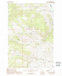
1988 Map of Cattle Gulch
USGS Topo · Published 1988About this map
The high elevations of the Beaverhead National Forest define this 1988 landscape, where mining history and rugged terrain intersect. Settlement centers on the small localities of Vipond and Glendale, with the latter featuring a local Cem and historical infrastructure including Kilns. The map provides a detailed view of the extraction economy that once drove this region, showing landmarks like the North Central Mine, West Limb Mine, and the La Marche Adit. The topography is marked by a complex drainage system flowing toward the Big Hole River along the eastern edge, with prominent features like Cattle Ridge and Nez Perce Ridge separating deep canyons and gulches. Remote water sources are well-documented, including Cattle Gulch Lake and several springs such as Upper Cattle Gulch Spring and Trusty Gulch Spring No 2, suggesting the historical importance of water management for both mining operations and high-country grazing.
Find a feature on this map
41 named features on this map. Tap any name to fly to it.
Don’t see what you’re looking for? This feature index may not catch every label — zoom into the map to look around manually.
Map Details
Editions of this 1988 Cattle Gulch Map
This is the sole edition of this map. No revisions or reprints were ever made.
Other maps of this area

1893 · Dillon
USGS Topo · 1:250,000

1955 · Dillon
USGS Topo · 1:250,000

1957 · Dillon
USGS Topo · 1:250,000

1958 · Dillon
USGS Topo · 1:250,000

1958 · Vipond Park
USGS Topo · 1:62,500

1961 · Melrose
USGS Topo · 1:24,000

1961 · Earls Gulch
USGS Topo · 1:24,000

1961 · Butte South
USGS Topo · 1:62,500

1961 · Dewey
USGS Topo · 1:24,000

1961 · Wise River
USGS Topo · 1:24,000