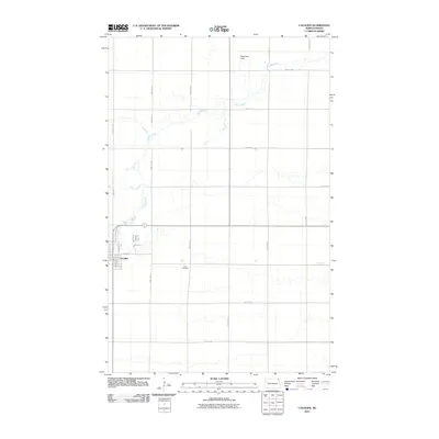
2011 Map of Cavalier
USGS Topo · Published 2011About this map
Cavalier serves as the focal point of this Red River Valley landscape, situated where the Tongue River winds through the flat agricultural terrain of Pembina County. The town's grid is well-defined, showing residential development along Grace Ave and Spruce Ln, with the commercial corridor centered on Main St E. This 2011 survey documents the established local infrastructure, from the aviation facilities at Magnuson Field to the north, to the quiet placement of Zion Cemetery to the east. The surrounding countryside is heavily organized by a strict sectional road system, including 143rd Ave NE and 95th St NE, which facilitates the region's expansive farming operations. The meandering path of the river provides a striking contrast to the geometric precision of the township and range lines that govern the rest of the quadrangle.
Find a feature on this map
23 named features on this map. Tap any name to fly to it.
Don’t see what you’re looking for? This feature index may not catch every label — zoom into the map to look around manually.
Map Details
Editions of this 2011 Cavalier Map
This is the sole edition of this map. No revisions or reprints were ever made.
Other maps of this area

1939 · Glasston
USGS Topo · 1:62,500

1939 · Cavalier
USGS Topo · 1:62,500

1941 · Glasston
USGS Topo · 1:62,500

1941 · Cavalier
USGS Topo · 1:62,500

1941 · Bathgate
USGS Topo · 1:62,500

1944 · Crystal
USGS Topo · 1:62,500

1952 · Thief River Falls
USGS Topo · 1:250,000

1956 · Thief River Falls
USGS Topo · 1:250,000

1957 · Thief River Falls
USGS Topo · 1:250,000
1964 · Hensel
USGS Topo · 1:24,000