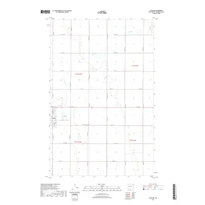
2017 Map of Cavalier
USGS Topo · Published 2017About this map
The city of Cavalier serves as the focal point of this Pembina County landscape, situated at the junction of the Tongue River and several key local corridors. The map details the town's grid, including Main St E, Division Ave N, and residential lanes like Spruce Ln and Grace Ave. The surrounding area is defined by the strict geometry of the Public Land Survey System, featuring large agricultural sections across townships T162N R54W and T161N R54W. A short distance south of the main settlement lies Zion Cem, a significant marker for genealogical research in the rural reaches of northeastern North Dakota. The Tongue River meanders across the prairie, its natural curves contrasting sharply with the rigid network of section-line roads such as 100th St NE and 143rd Ave NE.
Find a feature on this map
27 named features on this map. Tap any name to fly to it.
Don’t see what you’re looking for? This feature index may not catch every label — zoom into the map to look around manually.
Map Details
Editions of this 2017 Cavalier Map
This is the sole edition of this map. No revisions or reprints were ever made.
Other maps of this area

1939 · Glasston
USGS Topo · 1:62,500

1939 · Cavalier
USGS Topo · 1:62,500

1941 · Glasston
USGS Topo · 1:62,500

1941 · Cavalier
USGS Topo · 1:62,500

1941 · Bathgate
USGS Topo · 1:62,500

1944 · Crystal
USGS Topo · 1:62,500

1952 · Thief River Falls
USGS Topo · 1:250,000

1956 · Thief River Falls
USGS Topo · 1:250,000

1957 · Thief River Falls
USGS Topo · 1:250,000
1964 · Hensel
USGS Topo · 1:24,000