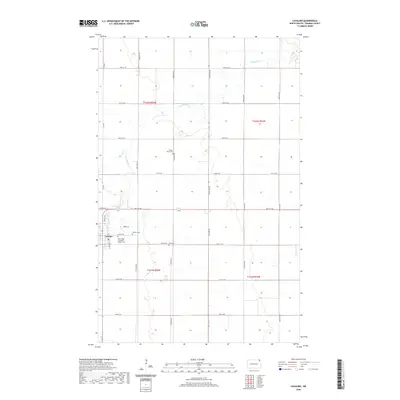
2020 Map of Cavalier
USGS Topo · Published 2020About this map
The town of Cavalier serves as the hub of this Red River Valley landscape, situated along the winding course of the Tongue River. The settlement pattern is defined by a rigorous grid of section-line roads, such as 142nd Ave NE and 96th St NE, which facilitate the expansive agricultural operations characteristic of Pembina County. This 2020 map provides significant detail for local historians and genealogists, specifically noting several burial sites scattered across the rural townships. While Cavalier Cem and the Saint Brigid of Ireland Catholic Cem are located near the town center, more remote locations like Tongue River Cem and Zion Cem to the east and south mark the historic sites of early prairie congregations. The terrain remains remarkably level, punctuated only by the subtle depression of the river valley as it moves toward the northeast.
Find a feature on this map
28 named features on this map. Tap any name to fly to it.
Don’t see what you’re looking for? This feature index may not catch every label — zoom into the map to look around manually.
Map Details
Editions of this 2020 Cavalier Map
This is the sole edition of this map. No revisions or reprints were ever made.
Other maps of this area

1939 · Glasston
USGS Topo · 1:62,500

1939 · Cavalier
USGS Topo · 1:62,500

1941 · Glasston
USGS Topo · 1:62,500

1941 · Cavalier
USGS Topo · 1:62,500

1941 · Bathgate
USGS Topo · 1:62,500

1944 · Crystal
USGS Topo · 1:62,500

1952 · Thief River Falls
USGS Topo · 1:250,000

1956 · Thief River Falls
USGS Topo · 1:250,000

1957 · Thief River Falls
USGS Topo · 1:250,000
1964 · Hensel
USGS Topo · 1:24,000