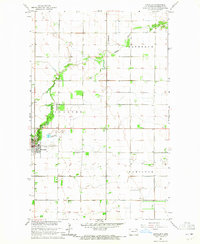
1964 Map of Cavalier
USGS Topo · Published 1965About this map
Cavalier serves as the focal point of this mid-1960s survey of the Red River Valley region, situated at the junction of organized townships and the winding Tongue River. The landscape is defined by the rigid grid of the Public Land Survey System, which contrasts with the irregular meanders of the river and the various Landing Strip facilities that support the local agricultural economy. Genealogists and local historians will find value in the precise locations of the municipal Cem and Zion Cem, alongside the development of local infrastructure such as the Sewage Disposal Ponds. The map provides a clear look at the boundaries between the Bathgate, Cavalier, and Hamilton districts during a period of steady Midwestern growth.
Find a feature on this map
9 named features on this map. Tap any name to fly to it.
Don’t see what you’re looking for? This feature index may not catch every label — zoom into the map to look around manually.
Map Details
Editions of this 1964 Cavalier Map
This is the sole edition of this map. No revisions or reprints were ever made.
Other maps of this area

1939 · Glasston
USGS Topo · 1:62,500

1939 · Cavalier
USGS Topo · 1:62,500

1941 · Glasston
USGS Topo · 1:62,500

1941 · Cavalier
USGS Topo · 1:62,500

1941 · Bathgate
USGS Topo · 1:62,500

1944 · Crystal
USGS Topo · 1:62,500

1952 · Thief River Falls
USGS Topo · 1:250,000

1956 · Thief River Falls
USGS Topo · 1:250,000

1957 · Thief River Falls
USGS Topo · 1:250,000
1964 · Hensel
USGS Topo · 1:24,000