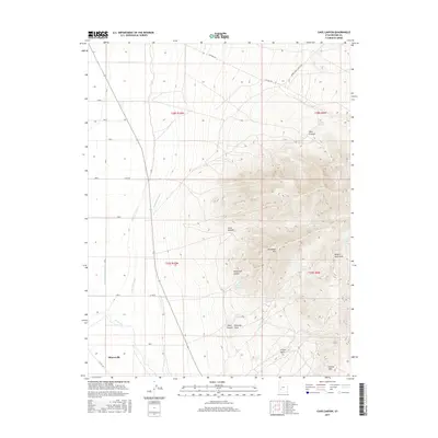
2017 Map of Cave Canyon
USGS Topo · Published 2017About this map
Minersville sits at the southwestern edge of this landscape, where the agricultural plains meet the rising slopes of the Mineral Mountains. The area's complex irrigation history is visible through a network of waterways including the High Line Canal, Low Line Canal, and Trans River Canal, which draw from the Beaver River to support the valley's farms. Moving east, the terrain climbs sharply into high peaks like Bradshaw Mtn and Yellow Mtn, dissected by deep drainage features such as Cave Canyon and Herb Eyre Hollow. This transition from managed water systems to high-desert mountains defines the region. Dozens of remote water sources are documented throughout the highlands, including Griffith Spring, Jimmy Jones Spring, and Shearing Corral Spring, which likely supported local livestock and ranching operations. Roads like The Pass Rd and Upper Ranch Canyon Rd provide the primary access into these higher elevations.
Find a feature on this map
29 named features on this map. Tap any name to fly to it.
Don’t see what you’re looking for? This feature index may not catch every label — zoom into the map to look around manually.
Map Details
Editions of this 2017 Cave Canyon Map
This is the sole edition of this map. No revisions or reprints were ever made.
Other maps of this area

1885 · Beaver
USGS Topo · 1:250,000

1953 · Ninemile Knoll
USGS Topo · 1:24,000

1953 · Milford Flat
USGS Topo · 1:24,000

1953 · Minersville
USGS Topo · 1:24,000

1953 · Cave Canyon
USGS Topo · 1:24,000

1953 · Richfield
USGS Topo · 1:250,000

1958 · Richfield
USGS Topo · 1:250,000

1958 · Minersville
USGS Topo · 1:62,500

1958 · Thermo
USGS Topo · 1:62,500

1958 · Milford
USGS Topo · 1:62,500