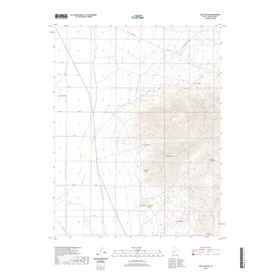
2020 Map of Cave Canyon
USGS Topo · Published 2020About this map
The Mineral Mountains dominate the eastern landscape of this Beaver County region, where high peaks descend into the expansive Escalante Desert. This desert environment is defined by an intricate network of irrigation infrastructure designed to manage the flow of the Beaver River, including the High Line Canal, Low Line Canal, and Trans River Canal. These systems demonstrate the vital role of water engineering in sustaining life and agriculture in Utah's arid basins. Tucked into the foothills and canyons are numerous water sources and topographic landmarks with specific local history value, such as Griffith Spring, Jimmy Jones Spring, and Herb Eyre Hollow. The transition from the steep elevations of Bradshaw Mtn and Yellow Mtn to the flatlands of the desert reveals the distinct geological and cultural boundaries of the area, as seen in the scattered ranch roads and canyons like Guyo Canyon and Cave Canyon.
Find a feature on this map
33 named features on this map. Tap any name to fly to it.
Don’t see what you’re looking for? This feature index may not catch every label — zoom into the map to look around manually.
Map Details
Editions of this 2020 Cave Canyon Map
This is the sole edition of this map. No revisions or reprints were ever made.
Other maps of this area

1885 · Beaver
USGS Topo · 1:250,000

1953 · Ninemile Knoll
USGS Topo · 1:24,000

1953 · Milford Flat
USGS Topo · 1:24,000

1953 · Minersville
USGS Topo · 1:24,000

1953 · Cave Canyon
USGS Topo · 1:24,000

1953 · Richfield
USGS Topo · 1:250,000

1958 · Richfield
USGS Topo · 1:250,000

1958 · Minersville
USGS Topo · 1:62,500

1958 · Thermo
USGS Topo · 1:62,500

1958 · Milford
USGS Topo · 1:62,500