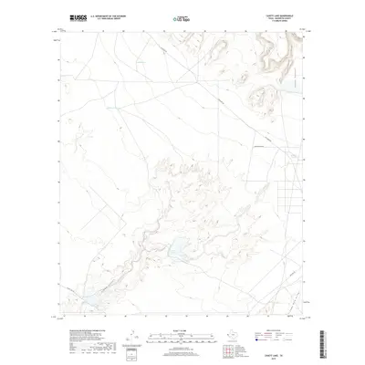
2019 Map of Cavett Lake
USGS Topo · Published 2019About this map
Cavett Lake lies at the heart of this arid Hudspeth County landscape, where water management is defined by a series of named tanks and catchments. The terrain is marked by significant drainage patterns, most notably the wide path of the Alamo Arroyo and the deeply etched Alamo Canyon to the northeast. Human presence in this section of the Chihuahuan Desert is characterized by remote utility roads and ranching infrastructure, including Phillip Tank and Caliche Tank, which serve as vital water points in a region dominated by seasonal washouts like Camp Rice Arroyo. The network of transit, including Mcguyers Rd and Alamo Lake Rd, illustrates the sparse but deliberate connectivity required to navigate these desert flats and canyons.
Find a feature on this map
11 named features on this map. Tap any name to fly to it.
Don’t see what you’re looking for? This feature index may not catch every label — zoom into the map to look around manually.
Map Details
Editions of this 2019 Cavett Lake Map
This is the sole edition of this map. No revisions or reprints were ever made.
Other maps of this area

1894 · Fort Hancock
USGS Topo · 1:125,000

1903 · Cerro Alto
USGS Topo · 1:125,000

1942 · Borrego
USGS Topo · 1:62,500

1943 · Tepee Butte
USGS Topo · 1:62,500

1943 · Finlay Mountains
USGS Topo · 1:62,500

1943 · Fort Hancock
USGS Topo · 1:62,500

1954 · Van Horn
USGS Topo · 1:250,000

1958 · Van Horn
USGS Topo · 1:250,000
1972 · Campo Grande Mountain
USGS Topo · 1:24,000
1972 · Fort Hancock NW
USGS Topo · 1:24,000