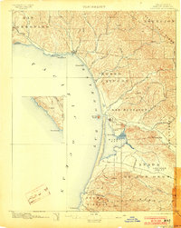
1897 Map of Cayucos
USGS Topo · Published 1903About this map
The central coast of San Luis Obispo County is defined by the steep transition from the Santa Lucia Range to the Pacific Ocean in this late nineteenth-century topographic study. The settlement of Cayucos sits near the northern shoreline, while further south, the landmark Morro Rock guards the entrance to Morro Bay. This era of the landscape is marked by large land grants including San Bernardo, San Luisito, and Cañada de los Osos y Pecho y Islay, reflecting the region's ranching heritage. Inland, the elevation rises sharply toward peaks like Hollister Peak and Valencia Peak, while numerous drainages such as Old Creek and Toro Creek carve through the coastal hills. The map provides a detailed look at the Los Osos Valley and its surrounding canyons before the significant development of the twentieth century.
Find a feature on this map
44 named features on this map. Tap any name to fly to it.
Don’t see what you’re looking for? This feature index may not catch every label — zoom into the map to look around manually.
Map Details
Editions of this 1897 Cayucos Map
5 editions found
Other maps of this area

1897 · Port Harford
USGS Topo · 1:62,500

1897 · San Luis Obispo
USGS Topo · 1:62,500

1897 · Cayucos
USGS Topo · 1:62,500

1897 · Arroyo Grande
USGS Topo · 1:62,500

1900 · San Luis
USGS Topo · 1:125,000

1919 · Paso Robles
USGS Topo · 1:62,500

1919 · Adelaida
USGS Topo · 1:62,500

1919 · San Simeon
USGS Topo · 1:62,500

1932 · Adelaida
USGS Topo · 1:62,500

1937 · Cayucos
USGS Topo · 1:62,500