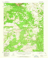
1955 Map of Cebolla
USGS Topo · Published 1965About this map
The Tierra Amarilla Grant dominates this northern New Mexico landscape, where the high country of the Carson National Forest meets a network of seasonal work sites and specialized mountain settlements. In the mid-1950s, the terrain was defined by a specific rural economy of timber and livestock, evidenced by the Hooker Sawmill and numerous high-altitude outposts like Crawthner Cow Camp, Peterson Cow Camp, and Johnson Cow Camp.
Find a feature on this map
54 named features on this map. Tap any name to fly to it.
Don’t see what you’re looking for? This feature index may not catch every label — zoom into the map to look around manually.
Map Details
Editions of this 1955 Cebolla Map
3 editions found
Other maps of this area

1909 · Gallina
USGS Topo · 1:125,000

1918 · Abiquiu
USGS Topo · 1:125,000

1918 · Tusas
USGS Topo · 1:125,000

1953 · Valle Grande Peak
USGS Topo · 1:24,000

1953 · Alire
USGS Topo · 1:24,000

1953 · Magote Peak
USGS Topo · 1:24,000

1953 · Canjilon
USGS Topo · 1:24,000

1954 · Aztec
USGS Topo · 1:250,000

1955 · Chama
USGS Topo · 1:62,500

1955 · Cebolla
USGS Topo · 1:62,500