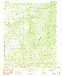
1983 Map of Cebolla
USGS Topo · Published 1983About this map
Cebolla and the high-elevation terrain of Rio Arriba County are the focus of this 1983 survey. The landscape is defined by the expansive Carson National Forest and the historical Tierra Amarilla Grant Boundary, showing a complex system of water rights and land use. High-country drainage is captured through a network of creeks and rivers, including Rio Nutrias and Rio Cebolla, which flow through steep canyons like the Cañada del Baño. The presence of several named springs, such as Dulce Spring, Amador Spring, and Fuertes Spring, highlights the critical importance of water sources in this northern New Mexico environment. Local industry and land modification are noted at a Gravel Pit near the river, while the settlement at Tonita and the recreation-focused Trout Lakes offer a look at the scattered human geography in this remote mountain region.
Find a feature on this map
23 named features on this map. Tap any name to fly to it.
Don’t see what you’re looking for? This feature index may not catch every label — zoom into the map to look around manually.
Map Details
Editions of this 1983 Cebolla Map
This is the sole edition of this map. No revisions or reprints were ever made.
Other maps of this area

1909 · Gallina
USGS Topo · 1:125,000

1918 · Abiquiu
USGS Topo · 1:125,000

1918 · Tusas
USGS Topo · 1:125,000

1953 · Alire
USGS Topo · 1:24,000

1953 · Magote Peak
USGS Topo · 1:24,000

1953 · Canjilon
USGS Topo · 1:24,000

1954 · Aztec
USGS Topo · 1:250,000

1955 · Cebolla
USGS Topo · 1:62,500

1955 · Tierra Amarilla
USGS Topo · 1:62,500

1958 · Aztec
USGS Topo · 1:250,000