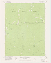
1979 Map of Cecil Lake
USGS Topo · Published 1979About this map
Klamath National Forest and Trinity National Forest meet in this high-altitude landscape within the Salmon-Trinity Alps Primitive Area. The map reveals a remote geography defined by historical pack trails and ephemeral mountain outposts, including Fosters Cabin and several former camp locations such as Five Dollar Camp and China Gardens Camp. These sites, often situated near vital water sources like Cecil Lake or Grizzly Creek, suggest a legacy of early backcountry exploration and resource management.
Find a feature on this map
41 named features on this map. Tap any name to fly to it.
Don’t see what you’re looking for? This feature index may not catch every label — zoom into the map to look around manually.
Map Details
Editions of this 1979 Cecil Lake Map
2 editions found
Other maps of this area

1909 · Big Bar
USGS Topo · 1:96,000

1915 · Big Bar and Vicinity
USGS Topo · 1:250,000

1948 · Weed
USGS Topo · 1:250,000

1950 · Weed
USGS Topo · 1:250,000

1951 · Helena
USGS Topo · 1:62,500

1951 · Ironside Mountain
USGS Topo · 1:62,500

1955 · Salmon Mtn
USGS Topo · 1:62,500

1955 · Cecilville
USGS Topo · 1:62,500

1958 · Redding
USGS Topo · 1:250,000

1958 · Weed
USGS Topo · 1:250,000