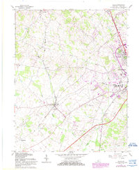
1967 Map of Cecilia
USGS Topo · Published 1987About this map
Cecilia and the western outskirts of Elizabethtown anchor this mid-century survey of Hardin County, which captures a landscape transitioning between traditional agricultural communities and modern infrastructure. The area is defined by a dense network of watercourses, including Pauley Creek, Billy Creek, and the various branches of Valley Creek, which dictate the local topography. This period shows the coexistence of established rural nodes like St John and Rineyville alongside emerging developments such as Helmwood Heights and the Elizabethtown Airport.
Find a feature on this map
34 named features on this map. Tap any name to fly to it.
Don’t see what you’re looking for? This feature index may not catch every label — zoom into the map to look around manually.
Map Details
Editions of this 1967 Cecilia Map
4 editions found
Other maps of this area

1932 · Big Clifty
USGS Topo · 1:62,500

1935 · Elizabethtown
USGS Topo · 1:48,000

1936 · Vine Grove
USGS Topo · 1:62,500

1938 · Elizabethtown
USGS Topo · 1:62,500

1941 · Ekron
USGS Topo · 1:62,500

1943 · Vine Grove
USGS Topo · 1:62,500

1946 · Colesburg
USGS Topo · 1:24,000

1946 · Vine Grove
USGS Topo · 1:24,000

1946 · Vine Grove
USGS Topo · 1:62,500

1947 · Ekron
USGS Topo · 1:62,500