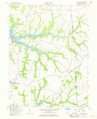
1958 Map of Cecilton
USGS Topo · Published 1968About this map
The agricultural lands of Middle Neck and Sassafras Neck define this mid-century portrait of the Maryland-Delaware border. Anchored by the crossroads of Cecilton and Warwick, the landscape is characterized by its deep-set tidal waterways, including the Bohemia River and Sassafras River. The map documents a rural society organized around small communities like St. Augustine and Cayots, where landmarks such as St. Francis Xavier Ch and Ebenezer Ch serve as local focal points.
Find a feature on this map
37 named features on this map. Tap any name to fly to it.
Don’t see what you’re looking for? This feature index may not catch every label — zoom into the map to look around manually.
Map Details
Editions of this 1958 Cecilton Map
3 editions found
Other maps of this area

1898 · Elkton
USGS Topo · 1:62,500

1899 · Dover
USGS Topo · 1:125,000

1900 · Elkton
USGS Topo · 1:62,500

1900 · Cecilton
USGS Topo · 1:62,500

1904 · Wilmington
USGS Topo · 1:62,500

1906 · Dover
USGS Topo · 1:125,000

1906 · Wilmington
USGS Topo · 1:62,500

1917 · Elkton
USGS Topo · 1:62,500

1919 · Wilmington
USGS Topo · 1:62,500

1920 · Dover
USGS Topo · 1:125,000