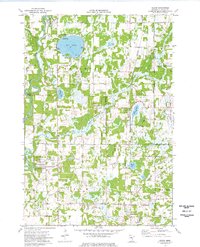
1974 Map of Cedar
USGS Topo · Published 1976About this map
Oak Grove and East Bethel dominate this mid-1970s landscape, where suburban growth meets the traditional lake country of Anoka County. The Rum River winds through the western edge of the quadrangle, punctuated by the Gaging Station and Gillespie Bridge. This era shows a community in transition, with established landmarks like St Patricks Ch and West Oak Grove Cem standing alongside new developments defined by a grid of numbered avenues and the prominent Burlington Northern rail corridor.
Find a feature on this map
42 named features on this map. Tap any name to fly to it.
Don’t see what you’re looking for? This feature index may not catch every label — zoom into the map to look around manually.
Map Details
Editions of this 1974 Cedar Map
2 editions found
Other maps of this area

1902 · White Bear
USGS Topo · 1:62,500

1902 · Anoka
USGS Topo · 1:62,500

1916 · St. Francis
USGS Topo · 1:62,500

1919 · St. Francis
USGS Topo · 1:62,500

1953 · Stillwater
USGS Topo · 1:250,000

1955 · Circle Pines
USGS Topo · 1:24,000

1955 · Anoka
USGS Topo · 1:24,000

1955 · Coon Rapids
USGS Topo · 1:24,000

1955 · Isanti
USGS Topo · 1:62,500

1955 · Anoka
USGS Topo · 1:62,500