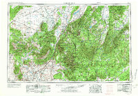
1953 Map of Cedar City
USGS Topo · Published 1973About this map
The Markagunt Plateau and Sevier Plateau dominate this 1950s study, where the abrupt transitions of the Pink Cliffs and White Cliffs illustrate the geology of Southern Utah. This edition reflects the mid-century infrastructure of the region, anchored by the Union Pacific RR crossing the Escalante Valley and the arterial routes of U S 91 and U S 89. It documents the early modern layout of settlements like Cedar City, St George, and Panguitch, alongside smaller communities such as Hamiltons Fort and Kanarraville. The map provides a detailed view of the high-country hydrology, tracing Panguitch Lake, Navajo Lake, and the headwaters of the Sevier River. Beyond the towns, the landscape is defined by federal and tribal lands, including the Kaibab Indian Reservation and the scenic borders of Zion National Park and Bryce Canyon National Park at a time when regional tourism was becoming a primary economic driver.
Find a feature on this map
95 named features on this map. Tap any name to fly to it.
Don’t see what you’re looking for? This feature index may not catch every label — zoom into the map to look around manually.
Map Details
Editions of this 1953 Cedar City Map
3 editions found

Other maps of this area

1885 · St. George
USGS Topo · 1:250,000

1885 · Beaver
USGS Topo · 1:250,000

1885 · Fish Lake
USGS Topo · 1:250,000

1885 · Pioche
USGS Topo · 1:250,000

1886 · Kanab
USGS Topo · 1:250,000

1886 · Escalante
USGS Topo · 1:250,000

1886 · Saint Thomas
USGS Topo · 1:250,000

1886 · Mt. Trumbull
USGS Topo · 1:250,000

1886 · Echo Cliffs
USGS Topo · 1:250,000

1886 · Pioche
USGS Topo · 1:250,000