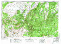
1953 Map of Cedar City
USGS Topo · Published 1974About this map
Cedar City serves as the gateway to a landscape defined by dramatic geologic staircase formations and the early industrial ventures of Southern Utah. This mid-century compilation reveals the sprawling reach of the Dixie National Forest and the proximity of Zion National Park and Bryce Canyon National Park to established valley settlements. The map documents the region's extraction history, from the Western Mine in the Iron Mountains to the legacy of the Silver Reef Mine near Leeds. Transportation patterns are fixed by the Union Pacific line crossing the Escalante Desert through Modena and Beryl, while local life is centered along the Virgin River and its tributaries. Significant cultural sites including the now-revered townsite of Grafton and the high-elevation Cedar Breaks Lodge appear alongside small agricultural outposts like Newcastle and New Harmony.
Find a feature on this map
115 named features on this map. Tap any name to fly to it.
Don’t see what you’re looking for? This feature index may not catch every label — zoom into the map to look around manually.
Map Details
Editions of this 1953 Cedar City Map
3 editions found

Other maps of this area

1885 · St. George
USGS Topo · 1:250,000

1885 · Beaver
USGS Topo · 1:250,000

1885 · Fish Lake
USGS Topo · 1:250,000

1885 · Pioche
USGS Topo · 1:250,000

1886 · Kanab
USGS Topo · 1:250,000

1886 · Escalante
USGS Topo · 1:250,000

1886 · Saint Thomas
USGS Topo · 1:250,000

1886 · Mt. Trumbull
USGS Topo · 1:250,000

1886 · Echo Cliffs
USGS Topo · 1:250,000

1886 · Pioche
USGS Topo · 1:250,000