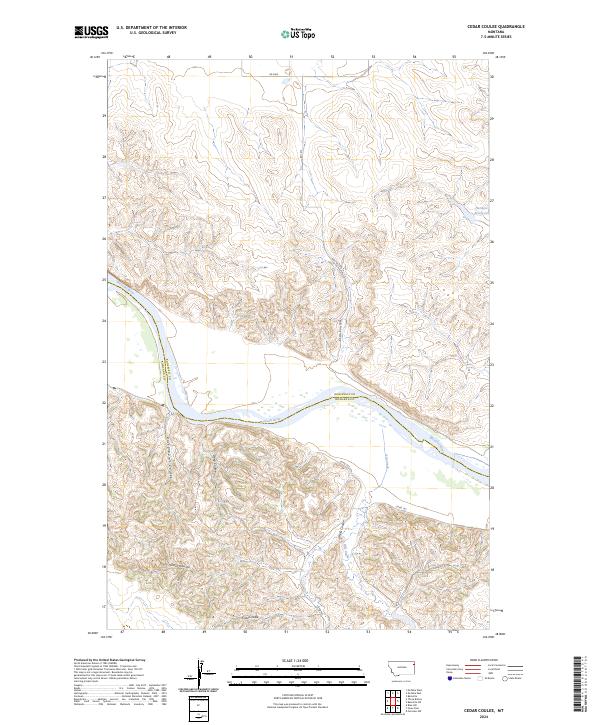
2024 Map of Cedar Coulee
USGS Topo · Published 2024About this map
The Missouri River cuts a wide, winding path through this portion of eastern Montana, serving as the natural boundary between Roosevelt and Richland counties. The landscape is defined by a dense network of erosional drainages that feed toward the river valley, including Cedar Coulee, Coal Coulee, and Star Coulee. These features illustrate the deeply dissected nature of the plains in this region, where intermittent watercourses have carved significant breaks into the high ground. To the north, Harmon Reservoir provides a managed water source amidst the ridgelines, while a series of rural routes such as RD 2060 and RD 1012 navigate the township and range lines. The map reveals the intricate topographic detail of the breaks near Rocky Point Coulee and Deep Coulee, offering a look at the land's character before modern developments changed the local grazing and agricultural patterns.
Find a feature on this map
19 named features on this map. Tap any name to fly to it.
Don’t see what you’re looking for? This feature index may not catch every label — zoom into the map to look around manually.
Map Details
Editions of this 2024 Cedar Coulee Map
This is the sole edition of this map. No revisions or reprints were ever made.
Other maps of this area

1909 · Glendive
USGS Topo · 1:250,000

1954 · Glendive
USGS Topo · 1:250,000

1954 · Wolf Point
USGS Topo · 1:250,000

1957 · Glendive
USGS Topo · 1:250,000

1958 · Wolf Point
USGS Topo · 1:250,000

1958 · Glendive
USGS Topo · 1:250,000

1969 · Cedar Coulee
USGS Topo · 1:24,000

1969 · Three Buttes
USGS Topo · 1:24,000

1969 · Bainville SW
USGS Topo · 1:24,000
1972 · Fairview NW
USGS Topo · 1:24,000