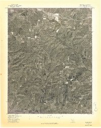
1977 Map of Cedar Gap
USGS Topo · Published 1977About this map
Cedar Gap and the surrounding Ozark plateau are captured in this 1977 orthophotograph, a specialized aerial survey produced in cooperation with the Soil Conservation Service. This document reveals the intricate texture of the landscape, where wooded ridges and steep ravines contrast sharply with the cleared agricultural plots on the flatter uplands. The drainage of Bryant Creek carves through the eastern portion of the quadrangle, dictating the patterns of local roads and property boundaries. Unlike traditional topographic maps, this imagery-based study provides a direct look at the vegetation cover and land use at the settlement of Mt Zion during the late 1970s. Researchers can examine the specific footprints of farmsteads and the density of timber in a region shaped by both its rugged geology and rural development.
Find a feature on this map
3 named features on this map. Tap any name to fly to it.
Don’t see what you’re looking for? This feature index may not catch every label — zoom into the map to look around manually.
Map Details
Editions of this 1977 Cedar Gap Map
This is the sole edition of this map. No revisions or reprints were ever made.
Other maps of this area

1936 · Ava
USGS Topo · 1:48,000

1937 · Bradleyville
USGS Topo · 1:48,000

1939 · Fordland
USGS Topo · 1:62,500

1942 · Fordland
USGS Topo · 1:62,500

1942 · Ava
USGS Topo · 1:62,500

1943 · Bradleyville
USGS Topo · 1:62,500

1945 · Ava
USGS Topo · 1:62,500

1945 · Harrison
USGS Topo · 1:250,000

1945 · Bradleyville
USGS Topo · 1:62,500

1949 · Harrison
USGS Topo · 1:250,000