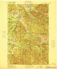
1913 Map of Cedar Lake
USGS Topo · Published 1916About this map
Snoqualmie National Forest dominates this landscape, showing a region defined by industrial expansion and water management in the early twentieth century. The map documents the Chicago Milwaukee and St Paul Railway and Northern Pacific Railway as they navigate the river valleys, connecting resource-rich outposts like Kerriston, Taylor, and Selleck to the larger economy. Timber and mining activities are evident through the presence of Page Mill, the Horseshoe Mine, and the Copper King Mine in the southern reaches.
Find a feature on this map
112 named features on this map. Tap any name to fly to it.
Don’t see what you’re looking for? This feature index may not catch every label — zoom into the map to look around manually.
Map Details
Editions of this 1913 Cedar Lake Map
5 editions found

Other maps of this area

1895 · Snohomish
USGS Topo · 1:125,000

1897 · Tacoma
USGS Topo · 1:125,000

1897 · Seattle
USGS Topo · 1:125,000

1900 · Tacoma
USGS Topo · 1:125,000

1901 · Snoqualmie Pass
USGS Topo · 1:125,000

1902 · Mount Aix
USGS Topo · 1:125,000

1902 · Skykomish
USGS Topo · 1:125,000

1903 · Snoqualmie
USGS Topo · 1:125,000

1904 · Mt Aix
USGS Topo · 1:125,000

1905 · Skykomish
USGS Topo · 1:125,000