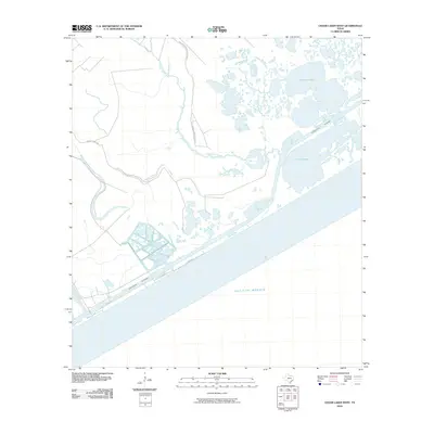
2010 Map of Cedar Lakes West
USGS Topo · Published 2010About this map
The San Bernard Wildlife Refuge occupies a significant portion of this coastal landscape, protecting a complex network of wetlands where the Cedar Lake Creek and Salt Bayou meet the Texas coast. The maritime character of the region is defined by the heavy engineering of the Intracoastal Waterway, which cuts a straight path through the natural estuaries of Cedar Lakes and Cowtrap Lake. This 2010 survey illustrates the precarious balance between preserved natural habitats and coastal development, visible in the residential grid along Canal Dr near the shoreline. Access to the interior is limited to a few arterial routes like Sargent Ranch Rd, emphasizing the watery isolation of the peninsula. The map serves as a precise record of the shoreline before subsequent years of coastal erosion and tropical weather altered these delicate marshlands and tidal basins.
Find a feature on this map
12 named features on this map. Tap any name to fly to it.
Don’t see what you’re looking for? This feature index may not catch every label — zoom into the map to look around manually.
Map Details
Editions of this 2010 Cedar Lakes West Map
This is the sole edition of this map. No revisions or reprints were ever made.
Other maps of this area

1943 · Jones Creek
USGS Topo · 1:31,680

1943 · Cedar Lakes East
USGS Topo · 1:24,000

1951 · Bay City
USGS Topo · 1:250,000

1952 · Cedar Lane NE
USGS Topo · 1:24,000

1952 · Cedar Lakes West
USGS Topo · 1:24,000
1952 · Brown Cedar Cut
USGS Topo · 1:24,000

1952 · Cedar Lane
USGS Topo · 1:24,000

1952 · Sargent
USGS Topo · 1:24,000

1956 · Bay City
USGS Topo · 1:250,000

1958 · Bay City
USGS Topo · 1:250,000