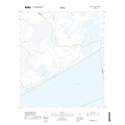
2019 Map of Cedar Lakes West
USGS Topo · Published 2019About this map
San Bernard Wildlife Refuge dominates this coastal landscape where the Texas shoreline meets the Gulf of Mexico. The map details a complex hydrologic network of brackish lagoons and marshes, centered on the Cedar Lakes and the expansive Cowtrap Lake. This 2019 survey illustrates the vital artery of the Intracoastal Waterway as it cuts through the marshland, providing a protected passage for maritime traffic. Inland, the terrain is defined by the winding course of Cedar Lake Creek and the tidal reaches of Salt Bayou. Transportation is limited to a few key corridors such as FM 457 Hwy and local routes like Sargent Ranch Rd, while the Cow Trap Marsh Trail offers one of the few named pedestrian paths through the protected wetlands. The boundary between Brazoria and Matagorda counties bisects the northeastern quadrant, marking the administrative limits in this ecologically sensitive region.
Find a feature on this map
13 named features on this map. Tap any name to fly to it.
Don’t see what you’re looking for? This feature index may not catch every label — zoom into the map to look around manually.
Map Details
Editions of this 2019 Cedar Lakes West Map
This is the sole edition of this map. No revisions or reprints were ever made.
Other maps of this area

1943 · Jones Creek
USGS Topo · 1:31,680

1943 · Cedar Lakes East
USGS Topo · 1:24,000

1951 · Bay City
USGS Topo · 1:250,000

1952 · Cedar Lane NE
USGS Topo · 1:24,000

1952 · Cedar Lakes West
USGS Topo · 1:24,000
1952 · Brown Cedar Cut
USGS Topo · 1:24,000

1952 · Cedar Lane
USGS Topo · 1:24,000

1952 · Sargent
USGS Topo · 1:24,000

1956 · Bay City
USGS Topo · 1:250,000

1958 · Bay City
USGS Topo · 1:250,000