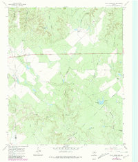
1967 Map of Cedar Mountain
USGS Topo · Published 1981About this map
The boundary between King County and Knox County divides this landscape of West Texas ranching and water management. Centered on the prominent rise of Cedar Mountain, the terrain is defined by deep cuts like Smelter Canyon and Little Getaway Canyon. The map documents a rugged cattle-country economy, noting several family operations including the Driver Ranch, Lyles Ranch, and Williams Ranch. Because water is the primary concern in this arid environment, the survey meticulously identifies man-made infrastructure such as the Coppermine Tank, Horseshoe Tank, and Big Tank. Essential landmarks for navigation and land use include the Croton Windmill and Little Dick Windmill, while a small prospect site near Smelter Creek hints at the mineral exploration that gave these canyons their names.
Find a feature on this map
22 named features on this map. Tap any name to fly to it.
Don’t see what you’re looking for? This feature index may not catch every label — zoom into the map to look around manually.
Map Details
Editions of this 1967 Cedar Mountain Map
2 editions found
Other maps of this area

1954 · Lubbock
USGS Topo · 1:250,000

1954 · Wichita Falls
USGS Topo · 1:250,000

1958 · Wichita Falls
USGS Topo · 1:250,000

1966 · Truscott South
USGS Topo · 1:24,000

1966 · Ox Yoke Creek
USGS Topo · 1:24,000

1966 · Maverick Flat
USGS Topo · 1:24,000

1967 · Cedar Mountain
USGS Topo · 1:24,000

1967 · Benjamin
USGS Topo · 1:24,000

1967 · Knox City NW
USGS Topo · 1:24,000

1967 · Kiowa Peak NE
USGS Topo · 1:24,000