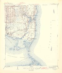
1943 Map of Cedar Point
USGS Topo · Published 1943About this map
Mon Louis Island dominates this coastal landscape, separated from the mainland by the winding course of the Fowl River. At the height of World War II, this map documents the established fishing and maritime communities along the Mobile Bay and Mississippi Sound shorelines. A significant historical detail is the G M and O (Abandoned) railroad line, illustrating the shifting transportation priorities of the era as rail service gave way to the Cedar Point Road corridor.
Find a feature on this map
53 named features on this map. Tap any name to fly to it.
Don’t see what you’re looking for? This feature index may not catch every label — zoom into the map to look around manually.
Map Details
Editions of this 1943 Cedar Point Map
4 editions found

Other maps of this area

1921 · Grand Bay
USGS Topo · 1:62,500

1921 · Petit Bois Island
USGS Topo · 1:62,500

1921 · Point Clear
USGS Topo · 1:62,500

1921 · Fairhope
USGS Topo · 1:62,500

1921 · Dauphin Island
USGS Topo · 1:62,500

1921 · Delchamps
USGS Topo · 1:62,500

1922 · Mobile
USGS Topo · 1:62,500

1939 · Daphne
USGS Topo · 1:31,680

1940 · Hollingers Island
USGS Topo · 1:31,680

1940 · Mobile
USGS Topo · 1:62,500