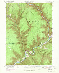
1946 Map of Cedar Run
USGS Topo · Published 1972About this map
Pine Creek dominates this landscape, carving a deep Gorge through the plateau as it snakes past the Tioga Co Lycoming Co boundary. The rail-and-river geography of the mid-20th century is evident here, with the Penn Central line following the river's narrow shelf through The Narrows. Small settlements like Leetonia, Blackwell, and Cedar Run are pockets of human activity in an area otherwise defined by steep drainages and timbered heights such as Callahan Hill and Gleason Hill.
Find a feature on this map
68 named features on this map. Tap any name to fly to it.
Don’t see what you’re looking for? This feature index may not catch every label — zoom into the map to look around manually.
Map Details
Editions of this 1946 Cedar Run Map
4 editions found
Other maps of this area

1937 · Waterville
USGS Topo · 1:48,000

1943 · Hyner
USGS Topo · 1:62,500

1943 · Waterville
USGS Topo · 1:62,500

1946 · Tiadaghton
USGS Topo · 1:24,000

1946 · Antrim
USGS Topo · 1:62,500

1946 · Renovo East
USGS Topo · 1:62,500

1946 · Cedar Run
USGS Topo · 1:24,000

1946 · Slate Run
USGS Topo · 1:24,000

1946 · Antrim
USGS Topo · 1:24,000

1946 · Morris
USGS Topo · 1:24,000
Featured Places
- Morris Township, PA
- Brown Township, PA
- Cedar Run, Brown Township
- Elk Township, PA
- Cedar Pines, Brown Township