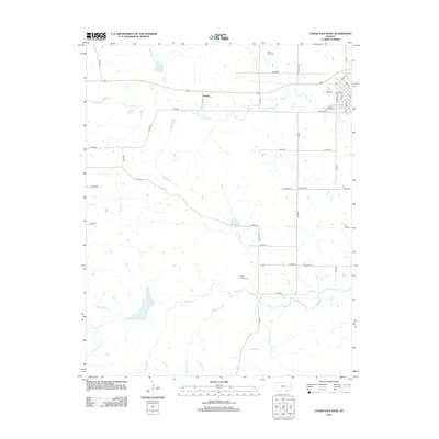
2012 Map of Cedar Vale West
USGS Topo · Published 2012About this map
The prairie landscape of southern Kansas is deeply etched by a network of waterways including Cedar Cr and Rock Cr in this 2012 survey of western Chautauqua County. The western edge of Cedar Vale is visible in the northeast, where the grid of Kingman Rd and State St meets the open country. This area represents a transition from town to rural acreage, centered on the small community of Taussig along the highway. Genealogists and local historians will find several burial grounds identified, including Cedar Creek Cem, Rock Creek Cem, and Cedar Vale Cem. The map illustrates a strictly organized section-line road system, with evocative names like Heritage Rd and Frontier Rd marking the boundaries between the rolling fields and the riparian corridors of Bear Cr and Whartenby Cr.
Find a feature on this map
46 named features on this map. Tap any name to fly to it.
Don’t see what you’re looking for? This feature index may not catch every label — zoom into the map to look around manually.
Map Details
Editions of this 2012 Cedar Vale West Map
This is the sole edition of this map. No revisions or reprints were ever made.
Other maps of this area
1885 · Sedan
USGS Topo · 1:125,000
1889 · Burden
USGS Topo · 1:125,000
1889 · Sedan
USGS Topo · 1:125,000
1909 · Pawhuska
USGS Topo · 1:125,000
1910 · Pawhuska
USGS Topo · 1:125,000
1916 · Foraker
USGS Topo · 1:62,500
1955 · Wichita
USGS Topo · 1:250,000
1955 · Enid
USGS Topo · 1:250,000
1958 · Enid
USGS Topo · 1:250,000
1958 · Wichita
USGS Topo · 1:250,000