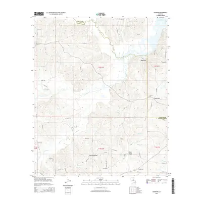
2015 Map of Cedarton
USGS Topo · Published 2015About this map
Bayou D'Arbonne Lake and the branching waters of the Middle Fork Bayou D'Arbonne dominate this northern Louisiana landscape where the borders of Union Parish and Lincoln Parish meet. The area is defined by a dense network of local creeks and branches, including Sixteen Br, Cypress Cr, and Smith Cr, which carve through the terrain south of Pea Ridge. Small communities and historic gathering points are scattered throughout the region, from the crossroads at Rock Corner and Mineral Springs to the northern settlement of Evergreen.
Find a feature on this map
83 named features on this map. Tap any name to fly to it.
Don’t see what you’re looking for? This feature index may not catch every label — zoom into the map to look around manually.
Map Details
Editions of this 2015 Cedarton Map
This is the sole edition of this map. No revisions or reprints were ever made.
Other maps of this area

1950 · Ruston
USGS Topo · 1:62,500

1951 · Ruston
USGS Topo · 1:62,500

1951 · Bernice
USGS Topo · 1:62,500

1952 · Calhoun
USGS Topo · 1:62,500

1952 · Farmerville
USGS Topo · 1:62,500

1955 · Shreveport
USGS Topo · 1:250,000

1956 · Shreveport
USGS Topo · 1:250,000
1982 · Downsville North
USGS Topo · 1:24,000
1982 · Downsville South
USGS Topo · 1:24,000

1984 · Shreveport
USGS Topo · 1:250,000