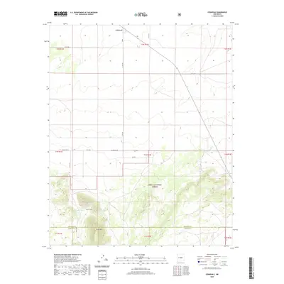
2020 Map of Cedarvale
USGS Topo · Published 2020About this map
Cedarvale serves as the primary landmark in this high-desert landscape of central New Mexico, where the plains of the Estancia Valley begin to rise toward the wooded slopes of the Cibola National Forest. The transition from open range to mountainous terrain is defined by prominent elevations like North Peak and Cougar Mtn, which dominate the southern half of the map. This area is characterized by its isolation and reliance on localized water sources such as Little Cougar Tank and Shartzer Tank. The rectilinear grid of rural routes, including Granquivera Rd and Anza Rd, reflects the organized land partitioning common in the West, even as it navigates the complex topography of the Torrance and Lincoln County line.
Find a feature on this map
26 named features on this map. Tap any name to fly to it.
Don’t see what you’re looking for? This feature index may not catch every label — zoom into the map to look around manually.
Map Details
Editions of this 2020 Cedarvale Map
This is the sole edition of this map. No revisions or reprints were ever made.
Other maps of this area

1954 · Fort Sumner
USGS Topo · 1:250,000

1958 · Fort Sumner
USGS Topo · 1:250,000

1980 · Corona
USGS Topo · 1:100,000

1981 · Rough Mountain
USGS Topo · 1:24,000

1981 · Progresso NE
USGS Topo · 1:24,000

1981 · Pino Mountain
USGS Topo · 1:24,000
1981 · Pajaro Canyon
USGS Topo · 1:24,000
1981 · Progresso SE
USGS Topo · 1:24,000
1981 · Cedarvale NE
USGS Topo · 1:24,000

1981 · Corona South
USGS Topo · 1:24,000