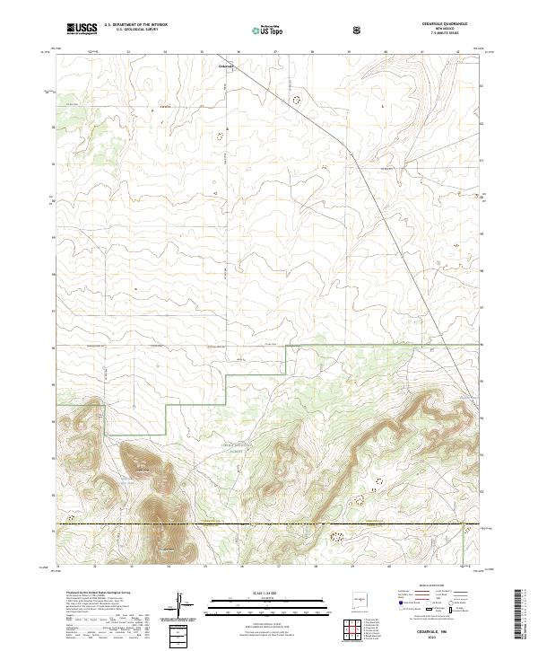
2023 Map of Cedarvale
USGS Topo · Published 2023About this map
Cedarvale serves as the primary settlement on this high-altitude landscape where the open plains of the northern section meet the rising elevations of the Cibola National Forest to the south. The terrain is defined by prominent peaks including North Peak and Cougar Mtn, which overlook a series of water catchment features such as Little Cougar Tank and Shartzer Tank. The map documents a transition from the structured township grid of the Estancia Basin into the more complex topography of the Gallinas Mountains. A network of county roads, including Granquivera Rd and Anza Rd, connects these remote ranching and forest lands, while the boundary between Torrance County and Lincoln County runs across the southern portion of the sheet.
Find a feature on this map
25 named features on this map. Tap any name to fly to it.
Don’t see what you’re looking for? This feature index may not catch every label — zoom into the map to look around manually.
Map Details
Editions of this 2023 Cedarvale Map
This is the sole edition of this map. No revisions or reprints were ever made.
Other maps of this area

1954 · Fort Sumner
USGS Topo · 1:250,000

1958 · Fort Sumner
USGS Topo · 1:250,000

1980 · Corona
USGS Topo · 1:100,000

1981 · Rough Mountain
USGS Topo · 1:24,000

1981 · Progresso NE
USGS Topo · 1:24,000

1981 · Pino Mountain
USGS Topo · 1:24,000
1981 · Pajaro Canyon
USGS Topo · 1:24,000
1981 · Progresso SE
USGS Topo · 1:24,000
1981 · Cedarvale NE
USGS Topo · 1:24,000

1981 · Corona South
USGS Topo · 1:24,000