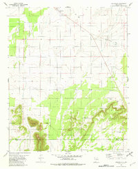
1981 Map of Cedarvale
USGS Topo · Published 1982About this map
Cedarvale serves as the focal point of this Central New Mexico landscape, situated at the junction of high-plains ranching and the wooded slopes of the Cibola National Forest. The map captures a transition from the level terrain of Torrance County into the more prominent relief of the south, dominated by Cougar Mountain and North Peak. A legacy of earlier transportation is clearly visible in the Old Railroad Grade cutting across the northeastern sections, while the distribution of water sources like Herring Windmill and numerous earthen catchments such as Lobo Tank and Corona Lake Tank underscore the area's reliance on managed water for livestock. Industrial activity is noted through scattered Drill Holes and a Gravel Pit, while a Radio Facility near the northern border points to contemporary infrastructure. The boundary between Torrance and Lincoln counties bisects the southern reaches, where the terrain becomes increasingly complex.
Find a feature on this map
17 named features on this map. Tap any name to fly to it.
Don’t see what you’re looking for? This feature index may not catch every label — zoom into the map to look around manually.
Map Details
Editions of this 1981 Cedarvale Map
This is the sole edition of this map. No revisions or reprints were ever made.
Other maps of this area

1954 · Fort Sumner
USGS Topo · 1:250,000

1958 · Fort Sumner
USGS Topo · 1:250,000

1980 · Corona
USGS Topo · 1:100,000

1981 · Rough Mountain
USGS Topo · 1:24,000

1981 · Progresso NE
USGS Topo · 1:24,000

1981 · Pino Mountain
USGS Topo · 1:24,000
1981 · Pajaro Canyon
USGS Topo · 1:24,000
1981 · Progresso SE
USGS Topo · 1:24,000
1981 · Cedarvale NE
USGS Topo · 1:24,000

1981 · Corona South
USGS Topo · 1:24,000