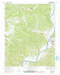
1968 Map of Celina
USGS Topo · Published 1990About this map
The Cumberland River and the rising waters of the Cordell Hull Reservoir dominate this 1960s study of the Kentucky and Tennessee borderlands. The town of Celina serves as a focal point where the Obey River joins the Cumberland, featuring essential civic infrastructure like the County Hospital and a Gaging Sta. The surrounding uplands are defined by a network of family-named hollows and ridges, such as Capshaw Hollow and Stephens Ridge, which were historically connected by rural settlements like Moss, Richville, and Arcott. For genealogists, the map is a dense record of early community life, preserving the locations of numerous country sanctuaries and graveyards, including Macedonia Ch, New Hope Cem, and McColgan Cem. This survey captures the landscape just as large-scale water management projects were reshaping the river valley's traditional agriculture and transport patterns.
Find a feature on this map
51 named features on this map. Tap any name to fly to it.
Don’t see what you’re looking for? This feature index may not catch every label — zoom into the map to look around manually.
Map Details
Editions of this 1968 Celina Map
4 editions found

Other maps of this area

1897 · Standingstone
USGS Topo · 1:125,000

1898 · Standingstone
USGS Topo · 1:125,000

1924 · Lillydale
USGS Topo · 1:62,500

1925 · Gainesboro
USGS Topo · 1:62,500

1926 · Lillydale
USGS Topo · 1:62,500

1929 · Lillydale
USGS Topo · 1:62,500

1929 · Gainesboro
USGS Topo · 1:62,500

1929 · Tompkinsville
USGS Topo · 1:62,500

1954 · Blacks Ferry
USGS Topo · 1:24,000

1954 · Tompkinsville
USGS Topo · 1:24,000