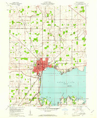
1960 Map of Celina
USGS Topo · Published 1961About this map
Celina serves as the focal point of this survey, positioned where the New York Chicago and St Louis RR tracks meet the northwest corner of Grand Lake. The city layout shows significant development during the early 1960s, featuring institutional markers like the Celina High School, Hospital, and West School. Nearby, the Livingston PO and a designated Fairground underscore the town's role as a regional hub for commerce and community gatherings.
Find a feature on this map
49 named features on this map. Tap any name to fly to it.
Don’t see what you’re looking for? This feature index may not catch every label — zoom into the map to look around manually.
Map Details
Editions of this 1960 Celina Map
3 editions found
Other maps of this area

1908 · St. Henry
USGS Topo · 1:62,500

1909 · Loramie
USGS Topo · 1:62,500

1911 · Loramie
USGS Topo · 1:62,500

1911 · Spencerville
USGS Topo · 1:62,500

1914 · Celina
USGS Topo · 1:62,500

1944 · Loramie
USGS Topo · 1:62,500

1944 · Celina
USGS Topo · 1:62,500

1944 · Spencerville
USGS Topo · 1:62,500

1953 · Muncie
USGS Topo · 1:250,000

1956 · Muncie
USGS Topo · 1:250,000