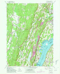
1963 Map of Cementon
USGS Topo · Published 1981About this map
Industrial quarrying and riverfront commerce define this stretch of the Hudson River valley during the early 1960s. The map illustrates the concentration of cement-related industry around Cementon, Alsen, and Smith Landing, where numerous quarries and gravel pits are cut into the eastern flank of the Kalkberg ridge. Along the river, the Conrail line and the New York State Thruway facilitate the movement of goods, while the Rip Van Winkle Bridge links the western settlements to Germantown and North Germantown on the eastern shore. Away from the industrial waterfront, the landscape rises into the foothills of Catskill Park, featuring recreational and social landmarks like Camp Rip Van Winkle and Camp On-Ti-Ora. The local community structure is recorded through numerous schools and churches, such as Kiskatom Ch and St Marys Ch, providing a detailed look at Greene County's mid-century development.
Find a feature on this map
59 named features on this map. Tap any name to fly to it.
Don’t see what you’re looking for? This feature index may not catch every label — zoom into the map to look around manually.
Map Details
Editions of this 1963 Cementon Map
4 editions found
Other maps of this area

1892 · Kaaterskill
USGS Topo · 1:62,500

1893 · Kaaterskill
USGS Topo · 1:62,500

1893 · Coxsackie
USGS Topo · 1:62,500

1893 · Durham
USGS Topo · 1:62,500

1894 · Coxsackie
USGS Topo · 1:62,500

1894 · Kaaterskill
USGS Topo · 1:62,500

1894 · Durham
USGS Topo · 1:62,500

1895 · Catskill
USGS Topo · 1:62,500

1899 · Kaaterskill
USGS Topo · 1:62,500

1903 · Kaaterskill
USGS Topo · 1:62,500