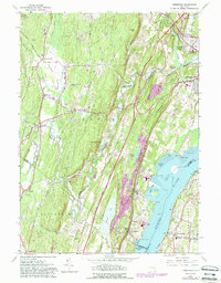
1963 Map of Cementon
USGS Topo · Published 1988About this map
The Hudson River shoreline is the industrial and transport heart of this landscape, where the Conrail line and historical settlements like Cementon and Alsen sit alongside extensive quarries. Inland, the terrain is defined by the sharp rise of Bethel Ridge and Timmerman Hill, while the Kaaterskill Creek and Kiskatom Brook carve drainage patterns toward the river valley. The map reveals a mix of old schoolhouses and spiritual centers, such as the Kiskatom Sch and St Marys Ch, situated near traditional crossroads.
Find a feature on this map
66 named features on this map. Tap any name to fly to it.
Don’t see what you’re looking for? This feature index may not catch every label — zoom into the map to look around manually.
Map Details
Editions of this 1963 Cementon Map
4 editions found
Other maps of this area

1892 · Kaaterskill
USGS Topo · 1:62,500

1893 · Kaaterskill
USGS Topo · 1:62,500

1893 · Coxsackie
USGS Topo · 1:62,500

1893 · Durham
USGS Topo · 1:62,500

1894 · Coxsackie
USGS Topo · 1:62,500

1894 · Kaaterskill
USGS Topo · 1:62,500

1894 · Durham
USGS Topo · 1:62,500

1895 · Catskill
USGS Topo · 1:62,500

1899 · Kaaterskill
USGS Topo · 1:62,500

1903 · Kaaterskill
USGS Topo · 1:62,500