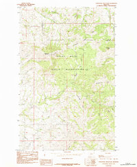
1984 Map of Centennial Mountain
USGS Topo · Published 1984About this map
Rocky Boys Indian Reservation encompasses a significant portion of this landscape along the border of Chouteau and Hill Counties. The area is defined by its complex drainage network, where Big Sandy Creek and Frenchman Creek gather water from the surrounding slopes. Higher elevations are marked by the prominent Centennial Mountain and Little Bear Peak, which overlook the dense Assneyewin Timber. The map provides a detailed record of indigenous and local nomenclature through numerous watercourses such as Okeyquuaakkeo, Oosahquapahmoo, and Mistiguenou Creek. This 1984 provisional survey documents the land before modern development, showing the transition from mountain ridges to the Salt Coulee and Goin Creek bottomlands. The intricate contours reveal the varied terrain of the Bearpaw Mountains region, which served as a critical habitat and resource area for the communities within the reservation.
Find a feature on this map
22 named features on this map. Tap any name to fly to it.
Don’t see what you’re looking for? This feature index may not catch every label — zoom into the map to look around manually.
Map Details
Editions of this 1984 Centennial Mountain Map
This is the sole edition of this map. No revisions or reprints were ever made.
Other maps of this area

1953 · Havre
USGS Topo · 1:250,000

1957 · Havre
USGS Topo · 1:250,000

1958 · Havre
USGS Topo · 1:250,000

1959 · Warrick
USGS Topo · 1:62,500

1959 · Laredo
USGS Topo · 1:62,500

1959 · Centennial Mountain
USGS Topo · 1:62,500

1959 · Shambo
USGS Topo · 1:62,500
1984 · Bearpaw Lake
USGS Topo · 1:24,000
1984 · Bowery Peak
USGS Topo · 1:24,000
1984 · Cowan Reservoir
USGS Topo · 1:24,000