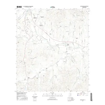
2016 Map of Center Point
USGS Topo · Published 2016About this map
The Guadalupe River carves a winding path through this portion of the Texas Hill Country, anchoring the settlements of Kerrville and Center Point. This 2016 survey highlights the transition between the expanding aviation facilities at Kerrville Municipal Airport/Louis Schreiner Field and the surrounding ranching and residential landscape. Numerous local cemeteries, including Wharton Cem, Center Point Cem, and Camp Verde Cem, offer critical data points for genealogical research, while landmarks like Lookout Mtn and Pikes Peak define the local topography. Further south, the community of Camp Verde sits near Verde Pass, indicating a long-established transit route through the hills. The map is heavily marked by named hollows such as Nowlin Hollow and Cottonwood Hollow, reflecting a deeply dissected landscape where water resources like Kerrville Lake and Center Point Lake are central to local settlement patterns.
Find a feature on this map
127 named features on this map. Tap any name to fly to it.
Don’t see what you’re looking for? This feature index may not catch every label — zoom into the map to look around manually.
Map Details
Editions of this 2016 Center Point Map
This is the sole edition of this map. No revisions or reprints were ever made.
Other maps of this area

1894 · Fredericksburg
USGS Topo · 1:125,000

1894 · Kerrville
USGS Topo · 1:125,000

1954 · Llano
USGS Topo · 1:250,000

1954 · San Antonio
USGS Topo · 1:250,000

1955 · Llano
USGS Topo · 1:250,000

1956 · Comfort
USGS Topo · 1:62,500

1956 · Center Point
USGS Topo · 1:62,500

1956 · Llano
USGS Topo · 1:250,000

1957 · San Antonio
USGS Topo · 1:250,000

1964 · Comfort
USGS Topo · 1:24,000