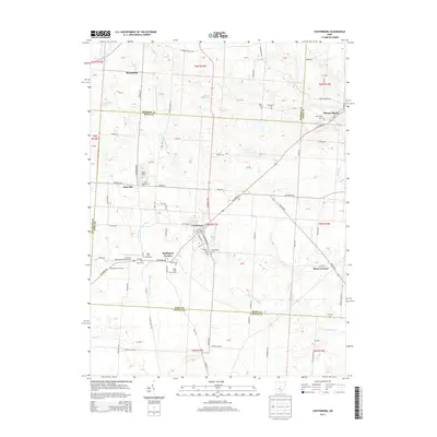
2013 Map of Centerburg
USGS Topo · Published 2013About this map
The Centerburg community sits at the geographic intersection of three Ohio counties, serving as a hub for the surrounding agricultural landscape where Hilliar Township meets its neighbors. This 2013 survey reveals the intricate drainage patterns of the N Fork Licking River and Otter Fork Licking River, which define the local topography. The map documents several small, historical settlements such as Mount Liberty to the northeast and Bloomfield to the northwest, alongside smaller crossroads like Hedington Corners and Myers Corners. Genealogists will find significant value in the numerous recorded burial sites, including Eastview Cem, Kile Cem, and the Lineweaver Cem. Modern land use is represented by Chapman Memorial Field Airport and the expansive Wyandot Golf Course, illustrating the evolution from purely agrarian roots to more diverse suburban and recreational development.
Find a feature on this map
98 named features on this map. Tap any name to fly to it.
Don’t see what you’re looking for? This feature index may not catch every label — zoom into the map to look around manually.
Map Details
Editions of this 2013 Centerburg Map
This is the sole edition of this map. No revisions or reprints were ever made.
Other maps of this area

1902 · Westerville
USGS Topo · 1:62,500

1904 · Westerville
USGS Topo · 1:62,500

1908 · Granville
USGS Topo · 1:62,500

1910 · Granville
USGS Topo · 1:62,500

1915 · Marengo
USGS Topo · 1:62,500

1915 · Fredericktown
USGS Topo · 1:62,500

1943 · Marengo
USGS Topo · 1:62,500

1943 · Fredericktown
USGS Topo · 1:62,500

1950 · Marion
USGS Topo · 1:250,000
1955 · Sunbury
USGS Topo · 1:24,000