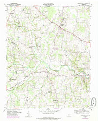
1953 Map of Centertown
USGS Topo · Published 1985About this map
Centertown serves as the focal point of this mid-century landscape where Warren, Cannon, and Coffee Counties converge. The topography is defined by the branching waterways of the Barren Fork, North Creek, and Willy Creek, which carved the undulating terrain that dictates the placement of early settlements and family farms. The map documents a deeply established rural community, evidenced by the numerous country churches and burial grounds such as Ivy Bluff Ch and the Poor House Cem.
Find a feature on this map
58 named features on this map. Tap any name to fly to it.
Don’t see what you’re looking for? This feature index may not catch every label — zoom into the map to look around manually.
Map Details
Editions of this 1953 Centertown Map
4 editions found

Other maps of this area

1893 · Mc Minnville
USGS Topo · 1:125,000

1895 · Mc Minnville
USGS Topo · 1:125,000

1908 · Woodbury
USGS Topo · 1:62,500

1913 · Hollow Springs
USGS Topo · 1:62,500

1936 · Fredonia
USGS Topo · 1:24,000

1936 · Petty Gap
USGS Topo · 1:24,000

1936 · Morrison
USGS Topo · 1:24,000

1942 · Statesville
USGS Topo · 1:100,000

1943 · Mc Minnville
USGS Topo · 1:100,000

1952 · Centertown
USGS Topo · 1:24,000