
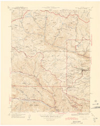
1944 Map of Central City
USGS Topo · Published 1944About this map
Central City serves as the focal point of this wartime survey, situated at the heart of the Gilpin County gold mining district. The landscape is densely packed with industrial legacy, from the prominent Glory Hole to the Grain O Mine and Pittsburg Mine. Beyond the primary settlement, the map reveals smaller mining camps and towns such as Nevadaville, Apex, and the remote Yankee, many of which were already entering a period of decline by the mid-1940s.
Find a feature on this map
92 named features on this map. Tap any name to fly to it.
Don’t see what you’re looking for? This feature index may not catch every label — zoom into the map to look around manually.
Map Details
Editions of this 1944 Central City Map
2 editions found
Other maps of this area

1899 · West Denver
USGS Topo · 1:125,000

1903 · Georgetown
USGS Topo · 1:62,500

1905 · Central City
USGS Topo · 1:62,500

1905 · Georgetown
USGS Topo · 1:62,500

1906 · Blackhawk
USGS Topo · 1:62,500

1910 · Central City
USGS Topo · 1:62,500

1912 · Central City
USGS Topo · 1:62,500

1942 · Nederland
USGS Topo · 1:24,000

1942 · Central City
USGS Topo · 1:24,000

1942 · Tungsten
USGS Topo · 1:24,000