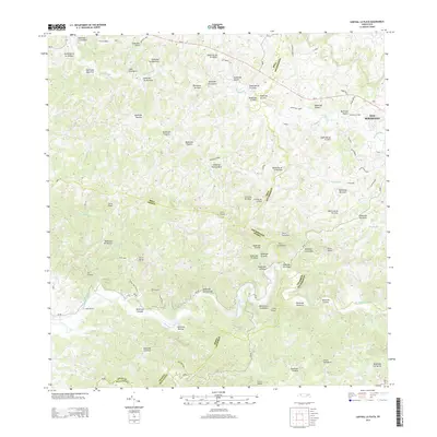
2013 Map of Central La Plata
USGS Topo · Published 2013About this map
Central La Plata and the surrounding highlands of northwestern Puerto Rico define this landscape, where the municipal boundaries of Moca, San Sebastián, and Añasco meet. This terrain is carved by an intricate network of waterways, including the winding Rio Culebrinas and its numerous tributaries such as Quebrada Dulce and Quebrada Agua Fría. The map details the transition from these river valleys to prominent peaks like Cerro Pichón and Cerro Pelao, illustrating the traditional agricultural and rural settlement patterns that have shaped the region. Notable local landmarks such as La Curena and the distinct ridgeline of Cuesta de la Yuca provide significant points of reference for those studying the land use and topography of this interior district. The road network, including PR-111 and PR-119, traces the contours of the hills, connecting isolated homesteads and small communities to the larger municipal centers.
Find a feature on this map
72 named features on this map. Tap any name to fly to it.
Don’t see what you’re looking for? This feature index may not catch every label — zoom into the map to look around manually.
Map Details
Editions of this 2013 Central La Plata Map
This is the sole edition of this map. No revisions or reprints were ever made.
Other maps of this area

1937 · Aguadilla
USGS Topo · 1:20,000

1937 · Moca
USGS Topo · 1:20,000

1938 · Alto Sano
USGS Topo · 1:20,000

1938 · San Sebastian
USGS Topo · 1:20,000

1938 · Quebradillas
USGS Topo · 1:20,000

1939 · Mayaguez
USGS Topo · 1:30,000

1941 · Moca
USGS Topo · 1:30,000

1941 · Rincon
USGS Topo · 1:30,000

1941 · Rincon
USGS Topo · 1:30,000

1941 · San Sebastian
USGS Topo · 1:30,000
Featured Places
- Sector Los Crespos, San Sebastián
- Sector La Grúa, Añasco
- Sector Serrano, San Sebastián
- Sector Bosque, Moca
- Sector Ramírez, Moca