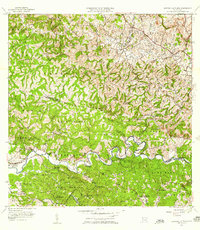
1955 Map of Central La Plata
USGS Topo · Published 1958About this map
The industrial operations at Central La Plata anchor the northeastern landscape of this interior Puerto Rican region, situated near the winding Rio Culebrinas. To the south, the Rio Grande de Anasco carves a deep valley through the mountains, separating the highlands of Casey Arriba and Naranjo from the northern barrios. This 1955 survey provides a clear view of an agrarian economy transitioning through the mid-20th century, where traditional landholdings like Hacienda Morales, Hacienda Esperanza, and Hacienda Mata remain prominent landmarks. The map also documents essential community infrastructure for the era, including the Centro Medico Barrio Espino and the Escuela Segunda Unidad de Anones, while tracing the path of the Old Rio Grande Road across the interior hills.
Find a feature on this map
69 named features on this map. Tap any name to fly to it.
Don’t see what you’re looking for? This feature index may not catch every label — zoom into the map to look around manually.
Map Details
Editions of this 1955 Central La Plata Map
This is the sole edition of this map. No revisions or reprints were ever made.
Other maps of this area

1937 · Aguadilla
USGS Topo · 1:20,000

1937 · Moca
USGS Topo · 1:20,000

1938 · Alto Sano
USGS Topo · 1:20,000

1938 · San Sebastian
USGS Topo · 1:20,000

1938 · Quebradillas
USGS Topo · 1:20,000

1939 · Mayaguez
USGS Topo · 1:30,000

1941 · Moca
USGS Topo · 1:30,000

1941 · Rincon
USGS Topo · 1:30,000

1941 · Rincon
USGS Topo · 1:30,000

1941 · San Sebastian
USGS Topo · 1:30,000
Featured Places
- Sector Serrano, San Sebastián
- Sector La Grúa, Añasco
- Sector Los Crespos, San Sebastián
- Sector Ramos, San Sebastián
- Sector Los Ramos, Moca