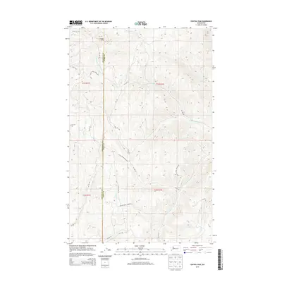
2014 Map of Central Peak
USGS Topo · Published 2014About this map
Central Peak anchors the high ground in this 2014 survey of the Colville Indian Reservation, where the landscape is defined by the sharp transition between mountainous terrain and a network of Bureau of Indian Affairs access roads. The summit is marked by the surveyor's monument MS 767 at the northern edge, serving as a primary elevation point for the surrounding ridges. Drainage patterns are dominated by the parallel courses of N-Nanamkin Cr and S-Nanamkin Cr flowing eastward, while Owhi Cr and Bear Cr carve through the northern and western sections. The map clearly delineates the administrative boundary between Okanogan and Ferry Counties, which runs vertically through the center of the sheet. This alignment illustrates how political boundaries often bisected these reservation lands, regardless of the natural topography or existing routes like Central Peak Rd.
Find a feature on this map
26 named features on this map. Tap any name to fly to it.
Don’t see what you’re looking for? This feature index may not catch every label — zoom into the map to look around manually.
Map Details
Editions of this 2014 Central Peak Map
This is the sole edition of this map. No revisions or reprints were ever made.
Other maps of this area

1950 · Nespelem
USGS Topo · 1:62,500

1952 · Keller
USGS Topo · 1:62,500

1953 · Seventeenmile Mtn.
USGS Topo · 1:62,500

1953 · Bald Knob
USGS Topo · 1:62,500

1954 · Okanogan
USGS Topo · 1:250,000

1958 · Okanogan
USGS Topo · 1:250,000

1984 · Nespelem
USGS Topo · 1:100,000

1986 · Central Peak
USGS Topo · 1:24,000
1989 · Stepstone Creek
USGS Topo · 1:24,000
1989 · Nespelem NE
USGS Topo · 1:24,000