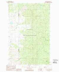
1989 Map of Nespelem NE
USGS Topo · Published 1989About this map
The Colville Indian Reservation dominates this mountainous landscape in north-central Washington during the late 1980s. Straddling the boundary between Okanogan Co and Ferry Co, the terrain is defined by a dense network of watercourses including the Little Nespelem River and Cache Creek. This provisional survey shows a wilderness largely focused on natural resources and high-altitude vantage points, evidenced by the Lookout Tower positioned on a prominent ridge and several Gravel Pits located near the river valley.
Find a feature on this map
9 named features on this map. Tap any name to fly to it.
Don’t see what you’re looking for? This feature index may not catch every label — zoom into the map to look around manually.
Map Details
Editions of this 1989 Nespelem NE Map
2 editions found
Other maps of this area

1950 · Nespelem
USGS Topo · 1:62,500

1952 · Keller
USGS Topo · 1:62,500

1953 · Seventeenmile Mtn.
USGS Topo · 1:62,500

1953 · Bald Knob
USGS Topo · 1:62,500

1954 · Okanogan
USGS Topo · 1:250,000

1958 · Okanogan
USGS Topo · 1:250,000

1984 · Nespelem
USGS Topo · 1:100,000

1986 · Central Peak
USGS Topo · 1:24,000
1989 · Keller
USGS Topo · 1:24,000
1989 · Stepstone Creek
USGS Topo · 1:24,000