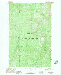
1989 Map of Central Peak
USGS Topo · Published 1989About this map
The Colville Indian Reservation encompasses this high-elevation landscape in the late 1980s, defined by the sharp topographic relief of the Broken Mountains and the prominent summit of Central Peak. The drainage patterns here are distinct, with Bear Creek and North Nanamkin Creek carving deep valleys through the rugged Okanogan Highlands. The boundary between Okanogan and Ferry counties runs directly through these peaks, following the natural ridgelines that divide the watersheds. This survey captures the area just before the turn of the decade, showing the intricate network of forest roads and trails that connect remote drainage systems like South Nanamkin Creek and Owhi Creek. The map is a detailed record of the natural geography and resource management boundaries within the reservation at this time.
Find a feature on this map
9 named features on this map. Tap any name to fly to it.
Don’t see what you’re looking for? This feature index may not catch every label — zoom into the map to look around manually.
Map Details
Editions of this 1989 Central Peak Map
This is the sole edition of this map. No revisions or reprints were ever made.
Other maps of this area

1950 · Nespelem
USGS Topo · 1:62,500

1952 · Keller
USGS Topo · 1:62,500

1953 · Seventeenmile Mtn.
USGS Topo · 1:62,500

1953 · Bald Knob
USGS Topo · 1:62,500

1954 · Okanogan
USGS Topo · 1:250,000

1958 · Okanogan
USGS Topo · 1:250,000

1984 · Nespelem
USGS Topo · 1:100,000

1986 · Central Peak
USGS Topo · 1:24,000
1989 · Stepstone Creek
USGS Topo · 1:24,000
1989 · Nespelem NE
USGS Topo · 1:24,000