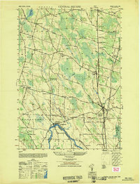
1949 Map of Central Square
USGS Topo · Published 1949About this map
Oneida River and the Oswego and Onondaga county line form the southern boundary of this late 1940s landscape. The village of Central Square serves as a local hub, where the intersection of major routes meets the New York Central railroad. This survey captures a rural network of named crossroads and hamlets, including East Palermo, Hastings Center, and the mills at Russes Mill.
Find a feature on this map
66 named features on this map. Tap any name to fly to it.
Don’t see what you’re looking for? This feature index may not catch every label — zoom into the map to look around manually.
Map Details
Editions of this 1949 Central Square Map
This is the sole edition of this map. No revisions or reprints were ever made.
Other maps of this area
1895 · Syracuse
USGS Topo · 1:62,500
1898 · Syracuse
USGS Topo · 1:62,500
1900 · Baldwinsville
USGS Topo · 1:62,500
1900 · Fulton
USGS Topo · 1:62,500
1905 · Mexico
USGS Topo · 1:62,500
1940 · Brewerton
USGS Topo · 1:24,000
1940 · Cicero
USGS Topo · 1:24,000
1943 · New Haven
USGS Topo · 1:31,680
1943 · Mallory
USGS Topo · 1:31,680
1943 · Brewerton
USGS Topo · 1:31,680