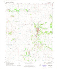
1972 Map of Centralia
USGS Topo · Published 1974About this map
Centralia serves as the focal point for this section of Craig County, shown here during the early 1970s. The settlement's layout is centered around a few primary streets and a prominent Water Tank, with the Centralia Cem situated to the northwest. The surrounding landscape is defined by its water system, where Clear Creek and Big Cabin Creek meander through the territory, joined by Salt Creek and Pawpaw Creek.
Find a feature on this map
18 named features on this map. Tap any name to fly to it.
Don’t see what you’re looking for? This feature index may not catch every label — zoom into the map to look around manually.
Map Details
Editions of this 1972 Centralia Map
This is the sole edition of this map. No revisions or reprints were ever made.
Other maps of this area

1901 · Vinita
USGS Topo · 1:125,000

1913 · Vinita
USGS Topo · 1:125,000

1954 · Tulsa
USGS Topo · 1:250,000

1958 · Tulsa
USGS Topo · 1:250,000

1963 · Tulsa
USGS Topo · 1:250,000
1971 · Pyramid Corners
USGS Topo · 1:24,000
1971 · Vinita
USGS Topo · 1:24,000
1971 · Welch NW
USGS Topo · 1:24,000
1972 · Estella
USGS Topo · 1:24,000
1972 · Sanders
USGS Topo · 1:24,000