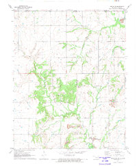
1971 Map of Welch NW
USGS Topo · Published 1973About this map
Strip mines dominate the landscape across this portion of Craig County in the early 1970s, illustrating the heavy industrial footprint of surface mining on the Oklahoma plains. The extraction sites are interspersed with a complex drainage network, where Big Cabin Creek and its tributaries, including Russell Creek and Wolf Creek, carve through the terrain. Significant energy infrastructure is evident through the extensive Gas Field and numerous Gas Wells that dot the countryside alongside a major pipeline corridor.
Find a feature on this map
19 named features on this map. Tap any name to fly to it.
Don’t see what you’re looking for? This feature index may not catch every label — zoom into the map to look around manually.
Map Details
Editions of this 1971 Welch NW Map
2 editions found
Other maps of this area

1886 · Parsons
USGS Topo · 1:125,000

1893 · Parsons
USGS Topo · 1:125,000

1901 · Vinita
USGS Topo · 1:125,000

1913 · Vinita
USGS Topo · 1:125,000

1944 · Oswego
USGS Topo · 1:62,500

1946 · Oswego
USGS Topo · 1:48,000

1946 · Mound Valley
USGS Topo · 1:62,500

1947 · Joplin
USGS Topo · 1:250,000
1948 · Oswego
USGS Topo · 1:62,500
1948 · Mound Valley
USGS Topo · 1:62,500