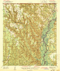
1943 Map of Century
USGS Topo · Published 1943About this map
The Escambia River defines the eastern boundary of this 1940s landscape, where a dense network of creeks like Pine Barren Creek and Canoe Creek cuts through the terrain. The region is anchored by two major rail lines: the Louisville and Nashville RR running north-south near the river, and the St Louis San Francisco RR serving the western uplands. This survey captures a rural social fabric built around small community centers such as Oak Grove and Walnut Hill. Numerous local landmarks provide rich detail for genealogists, including Coon Hill Cem and Juniper Cem, alongside local schools like Ward Sch and Davis Sch. The map illustrates a transitional era when agriculture and timber remained central, evidenced by the many named branches and small settlements like Bratt and McDavid that served as local hubs.
Find a feature on this map
60 named features on this map. Tap any name to fly to it.
Don’t see what you’re looking for? This feature index may not catch every label — zoom into the map to look around manually.
Map Details
Editions of this 1943 Century Map
2 editions found

Other maps of this area

1920 · Milton
USGS Topo · 1:62,500

1920 · Robertsdale
USGS Topo · 1:62,500

1921 · Muscogee
USGS Topo · 1:62,500

1941 · Muscogee
USGS Topo · 1:62,500

1941 · Robertsdale
USGS Topo · 1:62,500

1941 · Milton
USGS Topo · 1:62,500

1941 · Century
USGS Topo · 1:62,500

1942 · Perdido
USGS Topo · 1:62,500

1942 · Dyas
USGS Topo · 1:62,500

1943 · Robertsdale
USGS Topo · 1:62,500