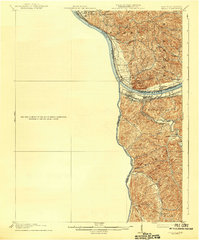
1913 Map of Ceredo
USGS Topo · Published 1942About this map
Kenova and Ceredo serve as the industrial anchors of this tri-state junction, where the Big Sandy River meets the Ohio River. The landscape is dominated by a complex network of transportation and river-borne commerce, with the Norfolk and Western Ry and the Chesapeake and Ohio RR converging on these strategic riverfront settlements. On the northern banks in Ohio, small communities like South Point, North Kenova, and Coalgrove line the shore, while the interior is dissected by numerous drainages such as Twelvepole Creek and Whites Creek. The map documents a period when these towns were crucial transfer points between rail and river, as evidenced by the dense development in the Westmoreland district and the scattered upland settlements like Centerville and Ryansville.
Find a feature on this map
41 named features on this map. Tap any name to fly to it.
Don’t see what you’re looking for? This feature index may not catch every label — zoom into the map to look around manually.
Map Details
Editions of this 1913 Ceredo Map
4 editions found

Other maps of this area

1892 · Huntington
USGS Topo · 1:125,000

1898 · Huntington
USGS Topo · 1:125,000

1898 · Ironton
USGS Topo · 1:62,500

1900 · Ironton
USGS Topo · 1:62,500

1901 · Guyandot
USGS Topo · 1:62,500

1901 · Ceredo
USGS Topo · 1:62,500

1902 · Guyandot
USGS Topo · 1:62,500

1903 · Kenova
USGS Topo · 1:125,000

1904 · Kenova
USGS Topo · 1:125,000

1906 · Athalia
USGS Topo · 1:62,500