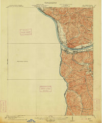
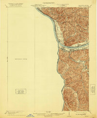
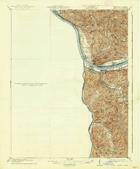
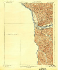
1913 Map of Ceredo
USGS Topo · Published 1913About this map
The Big Sandy River and Ohio River converge at the heart of this industrial and transit corridor during the early twentieth century. This survey, conducted by H.M. Wilson and W. N. Morrill, documents a landscape defined by its heavy rail infrastructure, where the Norfolk and Western, Chesapeake and Ohio, and B and O R R intersect near the strategic border towns of Kenova and Ceredo. The intricate drainage of the Twelvepole Creek basin reveals a network of smaller communities such as Rice and Centerville tucked into the interior valleys of Wayne County. Along the northern banks, Ohio settlements like Coalgrove and South Point face their West Virginia neighbors across the water. The map provides a detailed view of the region's topography before mid-century development, preserving the locations of early 1900s landings and rural creek-side habitations such as those along Whites Creek and Leatherwood Creek.
Find a feature on this map
37 named features on this map. Tap any name to fly to it.
Don’t see what you’re looking for? This feature index may not catch every label — zoom into the map to look around manually.
Map Details
Editions of this 1913 Ceredo Map
4 editions found
Other maps of this area

1892 · Huntington
USGS Topo · 1:125,000

1898 · Huntington
USGS Topo · 1:125,000

1898 · Ironton
USGS Topo · 1:62,500

1900 · Ironton
USGS Topo · 1:62,500

1901 · Guyandot
USGS Topo · 1:62,500

1901 · Ceredo
USGS Topo · 1:62,500

1902 · Guyandot
USGS Topo · 1:62,500

1903 · Kenova
USGS Topo · 1:125,000

1904 · Kenova
USGS Topo · 1:125,000

1906 · Athalia
USGS Topo · 1:62,500